Twister that hit Ont. town was an F3: Environment Canada


Environment Canada said on Monday that the devastating tornado that touched down in Goderich, Ont., levelling buildings and killing one, was an F3 with a path of destruction 500-metres wide.
The self-described "prettiest town in Canada" was hit Sunday by the most powerful tornado recorded in Ontario in more than a decade.
"This is the worst damage I've ever seen," Randy Mawson, an investigator with Environment Canada, told The Canadian Press.
Goderich Mayor Delbert Shewfelt promptly declared a state of emergency and on Monday, Ontario Premier Dalton McGuinty announced that the province had activated its emergency plan for helping communities struck by the disaster.
McGuinty said the immediate priority is to ensure that Goderich residents are safe, that they have power and that they can safely return to their homes, by setting aside $5 million to help recovery efforts.
That money is intended to help the municipality with some of the clean-up and recovery costs, McGuinty said, as well as to help home and business owners cope with uninsured losses.
"I want to reassure the people of Goderich: you are not on your own," McGuinty said Monday afternoon during a press conference in the town.
McGuinty said that during his 21 years in public office, he had "never seen devastation this extensive. It is significant. In fact, it can be overwhelming."
"This is not a matter from which you recover overnight. There's going to be some serious reconstruction involved."
Shewfelt then addressed reporters, describing the destruction as "just incredible."
"It's amazing what can come in off that lake," he said, vowing that the community "will recover."
Environment Canada estimates winds blew through the Lake Huron community at speeds approaching 300 kilometres per hour on Sunday at about 4 p.m.
Powerful winds
One man was killed by the sudden twister, which also injured at least 37 other people in the town of 8,000 located about 230 kilometres west of Toronto.
F3, or Fujita Scale 3, rating means that the tornado is "severe," according to Environment Canada. The type of damage expected with an F3 includes exterior walls and roofs blown off homes, metal buildings collapse or severely damaged, and forests and farmlands flattened.
F3's account for only about six per cent of all tornados.
Environment Canada senior climatologist David Phillips said Goderich residents were warned that the tornado was coming at 3:48 p.m., just 12 minutes before it hit on Sunday.
Phillips said tornado alerts are routinely issued 10 to 15 minutes in advance.
The warnings, which come through radio, mobile applications and other channels, urge people to take shelter, rather than focus on securing their possessions.
Phillips said the warnings encourage people to make sure their heads and necks are protected.
"It's not the wind that will get you, it's the flying debris that will hurt you," Phillips said.
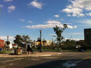
The morning after the twister tore through Goderich, fallen trees, broken glass, toppled cars and other debris were strewn about its downtown streets.
"It looks downtown simply like a bomb has gone off, there is no other way to describe it," CTV's Joel Bowey reported on Canada AM Monday morning.
Bowey said some buildings had been "completely levelled" by the tornado, while the strong winds had blown all the glass out of others.
The storm also downed power lines, tore roofs off of houses, and left cars and trees scattered along city streets.
"Cars have been toppled over, trees have gone through the windows of cars," Bowey said, noting that some 900 people were still without power early Monday morning.
Victim identified
Police confirmed a fatality late Sunday, naming Norman Laberge, of nearby Lucknow, Ont., as the male victim who died while working at the Sifto salt mine when the storm hit.
Bowey said there have been no other reports of fatalities stemming from the storm.
The tornado tore the roof off of Debbie Hakkers' home, which she crawled through on Monday morning to retrieve a laptop and jewelry box from her bedroom.
She was out shopping when the disaster struck. Her husband Gary, who was home when the tornado hit, is fine. But their home is in ruins.
"It's a total disaster," Hakkers said, wiping away tears on Monday.
"It never really hit me until this morning when I got up and came outside and I just cried."
The people who saw the tornado rip Goderich apart Sunday afternoon described the shock of witnessing the devastating twister.
Sean Carver said he watched the storm approach from his patio.
"The storm was quick, it blew through and it was gone," Carver told The Canadian Press.
"The so-called scary part is literally only about two minutes, half an instant, and then the winds go back down to about 80 kilometres an hour, but you know you're safe again."
At Joe Roosemalen's house, the first sign of trouble was when the power started flickering. He was hosting a Sunday afternoon birthday party for his daughter and her friends when the storm hit.
"I basically looked out the window and just saw the twister right in front of us,"
Roosemalen told CTV's Canada AM in a telephone interview on Monday morning.
Ushering his daughter and her guests into his basement, Roosemalen said they quickly caught on to what was happening.
"It was pretty much a panic," he said.
Waking up a day after the devastation, Roosemalen said he has a hydro pole "sitting against the front door of the house and on top of the roof," as well as a backyard filled with fallen trees.


The self-described "prettiest town in Canada" was hit Sunday by the most powerful tornado recorded in Ontario in more than a decade.
"This is the worst damage I've ever seen," Randy Mawson, an investigator with Environment Canada, told The Canadian Press.
Goderich Mayor Delbert Shewfelt promptly declared a state of emergency and on Monday, Ontario Premier Dalton McGuinty announced that the province had activated its emergency plan for helping communities struck by the disaster.
McGuinty said the immediate priority is to ensure that Goderich residents are safe, that they have power and that they can safely return to their homes, by setting aside $5 million to help recovery efforts.
That money is intended to help the municipality with some of the clean-up and recovery costs, McGuinty said, as well as to help home and business owners cope with uninsured losses.
"I want to reassure the people of Goderich: you are not on your own," McGuinty said Monday afternoon during a press conference in the town.
McGuinty said that during his 21 years in public office, he had "never seen devastation this extensive. It is significant. In fact, it can be overwhelming."
"This is not a matter from which you recover overnight. There's going to be some serious reconstruction involved."
Shewfelt then addressed reporters, describing the destruction as "just incredible."
"It's amazing what can come in off that lake," he said, vowing that the community "will recover."
Environment Canada estimates winds blew through the Lake Huron community at speeds approaching 300 kilometres per hour on Sunday at about 4 p.m.
Powerful winds
One man was killed by the sudden twister, which also injured at least 37 other people in the town of 8,000 located about 230 kilometres west of Toronto.
F3, or Fujita Scale 3, rating means that the tornado is "severe," according to Environment Canada. The type of damage expected with an F3 includes exterior walls and roofs blown off homes, metal buildings collapse or severely damaged, and forests and farmlands flattened.
F3's account for only about six per cent of all tornados.
Environment Canada senior climatologist David Phillips said Goderich residents were warned that the tornado was coming at 3:48 p.m., just 12 minutes before it hit on Sunday.
Phillips said tornado alerts are routinely issued 10 to 15 minutes in advance.
The warnings, which come through radio, mobile applications and other channels, urge people to take shelter, rather than focus on securing their possessions.
Phillips said the warnings encourage people to make sure their heads and necks are protected.
"It's not the wind that will get you, it's the flying debris that will hurt you," Phillips said.
The morning after the twister tore through Goderich, fallen trees, broken glass, toppled cars and other debris were strewn about its downtown streets.
"It looks downtown simply like a bomb has gone off, there is no other way to describe it," CTV's Joel Bowey reported on Canada AM Monday morning.
Bowey said some buildings had been "completely levelled" by the tornado, while the strong winds had blown all the glass out of others.
The storm also downed power lines, tore roofs off of houses, and left cars and trees scattered along city streets.
"Cars have been toppled over, trees have gone through the windows of cars," Bowey said, noting that some 900 people were still without power early Monday morning.
Victim identified
Police confirmed a fatality late Sunday, naming Norman Laberge, of nearby Lucknow, Ont., as the male victim who died while working at the Sifto salt mine when the storm hit.
Bowey said there have been no other reports of fatalities stemming from the storm.
The tornado tore the roof off of Debbie Hakkers' home, which she crawled through on Monday morning to retrieve a laptop and jewelry box from her bedroom.
She was out shopping when the disaster struck. Her husband Gary, who was home when the tornado hit, is fine. But their home is in ruins.
"It's a total disaster," Hakkers said, wiping away tears on Monday.
"It never really hit me until this morning when I got up and came outside and I just cried."
The people who saw the tornado rip Goderich apart Sunday afternoon described the shock of witnessing the devastating twister.
Sean Carver said he watched the storm approach from his patio.
"The storm was quick, it blew through and it was gone," Carver told The Canadian Press.
"The so-called scary part is literally only about two minutes, half an instant, and then the winds go back down to about 80 kilometres an hour, but you know you're safe again."
At Joe Roosemalen's house, the first sign of trouble was when the power started flickering. He was hosting a Sunday afternoon birthday party for his daughter and her friends when the storm hit.
"I basically looked out the window and just saw the twister right in front of us,"
Roosemalen told CTV's Canada AM in a telephone interview on Monday morning.
Ushering his daughter and her guests into his basement, Roosemalen said they quickly caught on to what was happening.
"It was pretty much a panic," he said.
Waking up a day after the devastation, Roosemalen said he has a hydro pole "sitting against the front door of the house and on top of the roof," as well as a backyard filled with fallen trees.